Class 11 Geography NCERT Solutions Chapter 2 Structure and Physiography
False______________________________________________________________________________________________________________
1. Choose the right answer from the four alternatives given below: 1. Choose the right answer from the four alternatives given below: 1. Choose the right answer from the four alternatives given below: 1. Choose the right answer from the four alternatives given below: 1. Choose the right answer from the four alternatives given below: 2. Choose the right answer from the four alternatives given below: 3. Choose the right answer from the four alternatives given below: 4. Choose the right answer from the four alternatives given below: 3. Choose the right answer from the four alternatives given below: 4. Choose the right answer
Question 1(i).
In which part of Himalayas do we find the Karewa formation?
(a) North-eastern Himalayas
(b) Himachal-Uttarakhand Himalayas
(c) Eastern Himalayas
(d) Kashmir Himalayas
Answer:
(d) Kashmir Himalayas
Question 1(ii).
In which of the following states is Loktak lake situated?
(a) Kerala
(b) Uttarakhand
(c) Manipur
(d) Rajasthan
Answer:
(c) Manipur
Question 1(iii).
Which one of the water bodies separates the Andaman from the Nicobar?
(a) 11° Channel
(b) Gulf of Mannar
(c) 10° Channel
(d) Andaman Sea
Answer:
(a) 11° Channel
Question 1(iv).
On which of the following hill range is the ‘Dodabeta’ peak situated?
(a) Nilgiri hills
(b) Anaimalai hills
(c) Cardamom hills
(d) Nallamala hills
Answer:
(a) Nilgiri hills
True
Question 2(i).
If a person is to travel to Lakshadweep, from which coastal plain does he prefer and why?
Answer:
Lakshadweep islands are situated in Arabian Sea. These islands are located at a distance of 280 km-480 km off the Kerala coast. Its distance is lowest from Malabar Coast. Therefore, it will take us least time to reach at Lakshadweep islands from Malabar Coast.
Question 2(ii).
Where in India will you find a cold desert? Name some important ranges of this region.
Answer:
The north-eastern part of the Kashmir Himalayas is a cold desert, which lies between the Greater Himalayas and the Karakoram ranges. Main ranges of this region are Laddakh, Karakoram, Jasker and Pir Panjal.
Question 2(iii).
Why is the western coastal plain is devoid of any delta?
Answer:
The slope of rivers of western coast is very steep. Therefore, these rivers flow not in different parts but in one part. And hence they do not form any delta. As a result, we do not find any delta in the western coast.
True
Question 3(i).
Make a comparison of the island groups of the Arabian Sea and the Bay of Bengal.
Answer:
Lakshadweep islands are in Arabian Sea and Andaman and Nicobar islands are in Bay of Bengal.
imageee
Question 3(ii).
What are the important geomorphological features found in the river valley plains?
Answer:
Alluvial fans are formed when streams flowing from higher levels break into foot slope plains of low gradient. Normally very coarse load is carried by streams flowing over mountain slopes. This load becomes too heavy for the streams to be carried over gentler gradients and gets dumped and spread as a broad low to high cone shaped deposit called alluvial fan. Usually, the streams which flow over fans are not confined to their original channels for long and shift their position across the fan forming many channels called distributaries. Alluvial fans in humid areas show normally low cones with gentle slope form as a low cone.
Falk: delta is like alluvial fans but develop at a different location . the load carried by the rivers is dumped and spread into the sea . flood deposits of spilled waters carry relatively finer materials like silt and clay .
True
Question 3(iii).
If you move from Badrinath to Sunderbans delta along the coarse of the river Ganga, what major geomorphological features will you come across?
Answer:
If we move from Badrinath to Sunderbans delta along the course of the river Ganga, following major geomorphological features will we come across:
True
False
True
False
True
Paraphrase: Project/Activity/Project/Activity/Project/Activity/Project/Activity/Project/Activity/Project/Activity/Project/Activity/Project/Activity/Project/Activity/Project/Activity/Project/Activity/Project/Activity/Project/Activity/Project/Activity/Project/Activity/Project/Activity/Project/Activity/Project/Activity/Project/
(i) Make a list of major Himalayan peaks from the west to the east with the help of an atlas.
Ans, Attempt yourself.
(ii) Identify the major landforms of your state and analyse the major economic activity practised by the people in each landform.
Answer:
Attempt yourself.
Ref: Class 11 Geography Chapter 2 NCERT Extra Questions NCERT Extra Questions NCERT Extra Questions NCERT Extra Questions NCERT Extra Questions NCERT Extra Questions NCERT Extra Questions NCERT Extra Questions NCERT Extra Questions NCERT Extra Questions NCERT Extra Questions NCERT Extra Questions NCERT Extra Questions NCERT Extra Questions NCERT Extra Questions NCERT Extra Questions NCERT Extra Questions NCERT Extra Questions NCERT Extra Questions NCERT Extra Questions NCERT Extra Questions NCERT Extra Questions NCERT Extra Questions
False______________________________________________________________________________________________________________
Question 1.
Which of the following is the highest peak of western ghats?
(a) Anaimudi
(b) Nilgiri
(c) Mahendragiri
(d) Barabar.
Answer:
(a) Anaimudi
Question 2.
Which of the following is not a part of Meghalaya Plateau?
(а) The Garo Hills
(b) The Khasi Hills
(c) The Jaintia Hills
(d) Kaimoor Hills.
Answer:
(d) Kaimoor Hills
Question 3.
Old alluvial soil is called:
(a) Khadar
(b) Bangar
(c) Bhabar
(d) Kareva.
Answer:
(b) Bangar
Question 4.
New alluvial soil is called:
(a) Khadar
(b) Bangar
(c) Bhabar
(d) Kareva.
Answer:
(a) Khadar
Question 5.
Which of the following hills are not a part of eastern ghats?
(a) Javadi hills
(b) Nallamala hills
(c) Nilgiri hills
(d) Mahendragiri hills.
Answer:
(c) Nilgiri hills
Question 6.
Which of the following hills are not a part of western ghats?
(a) Anaimalai hills
(b) Nilgiri hills
(c) Cardamom hills
(d) Palconda range,
Answer:
(d) Palconda range
Question 7.
Lesser Himalayas is called by what name in Uttaranchal?
(a) Dholadhar
(b) Nagtia
(c) Kayal
(d) Kareva.
Answer:
(b) Nagtia
Question 8.
Which of the following is not included in central highlands?
(a) Satpura ranges
(b) Vindhyan ranges
(c) Kaimur ranges
(d) Mahendragiri ranges.
Answer:
(d) Mahendragiri ranges
Question 9.
Which of the following is not a tributary of river Brahmaputra?
(a) Subansiri
(b) Dihang
(c) Kormang
(d) Morhar.
Answer:
(d) Morhar
Question 10.
Which of the following is not a tribe living in Arunachal Himalayas?
(a) Monpa, Daffla
(b) Abor, Mishmi
(c) Nishi, Nagas
(d) Manjhi, Dusadh.
Answer:
(d) Manjhi, Dusadh
Question 11.
What is the east-west length of greater Himalayas?
(a) 2000 km
(b) 2500 km
(c) 3000 km
(d) 3200 km.
Answer:
(b) 2500 km.
False
Question 1.
What are Dims?
Answer:
Duns are flat-floored structural valleys between the Siwalik and Himachal.
For example: Dehradun.
Question 2.
What are North-western Himalayas?
Answer:
It comprise a series of ranges such as the Karakoram, Ladakh, Zaskar and Pir Panjal. The north-eastern part of the Kashmir Himalayas is a cold desert, which lies between the Greater Himalayas and the Karakoram ranges.
Question 3.
What are central highlands?
Answer:
These are bounded by the Aravalli range to the west, the satpura range on the north generally at an elevation varying between 600 m to 900 m.
Question 4.
In how many categories can Himalayas be divided on the basis of relief, alignment of ranges and other geomorphological features?
Answer:
On the basis of relief, alignment of ranges and other geomorphological features, the Himalayas can be divided into the following sub-divisions:
- Kashmir or North-western Himalayas
- Himachal and Uttaranchal Himalayas
- Daijeeling and Sikkim Himalayas
- Arunachal Himalayas
- Eastern Hills and Mountains.
Question 5.
In how many divisions can India be divided physiographically?
Answer:
India can be divided into the following physiographic divisions:
- The Northern and North-eastern Mountains.
- The Northern Plain.
- The Peninsular Plateau.
- The Indian Desert.
- The Coastal Plains.
- The Islands.
Question 6.
Based on the variations in its geological structure and formations, in how many categories can India be divided?
Answer:
India can be divided into three geological divisions. These geological regions broadly follow the physical features:
- The Peninsular Block.
- The Himalayas and other Peninsular Mountains.
- Indo-Ganga-Brahmaputra Plain.
Question 7.
When and how was Indo-Ganga- Brahmaputra plain was formed?
Answer:
Indo-Ganga-Brahmaputra Plain is a geological division of India that comprises the plains formed by the river Indus, the Ganga and the Brahmaputra. Originally, it was a geo-synclinal depression which attained its maximum development during the third phase of the Himalayan mountain formation approximately about 64 million years ago. Since then, it has been gradually filled by the sediments brought by the Himalayan and Peninsular rivers.
Question 8.
What is called Molassis basin?
Answer:
Manipur is also called Molassis basin.
Question 9.
What is Bhabar?
Answer:
Bhabar is a narrow belt ranging between 8-10 km parallel to the Shiwalik foothills at the break-up of the slope. As a result of this, the streams and rivers coming from the mountains deposit heavy materials of rocks and boulders, and at times, disappear in this zone.
Question 10.
What is tarai?
Answer:
South of the Bhabar is the Tarai belt, with an approximate width of 10-20 km where most of the streams and rivers re-emerge without having any properly demarcated channel, thereby,’creating marshy and swampy conditions known as the Tarai.
Question 11.
What are the local names given to Western Ghats?
Answer:
Western Ghats are locally known by different names such as Sahyadri in Maharashtra, Nilgiri hills in Karnataka and Tamil Nadu and Anaimalai hills and Cardamom hills in Kerala.
Question 12.
Where is Nehru Trophy Vallamkali held?
Answer:
The Nehru Trophy Vallamkali (boat race) is held in Punnamada kayal in Kerala.
Question 13.
Name some important ports on the eastern coast?
Answer:
Tuticorian, Vishakhapatnam, Paradeep, Chennai, Kolkata are important ports.
Question 14.
Give sub divisions of Meghalaya Plateau.
Answer:
The Meghalaya plateau is further sub-divided into three:
- The Garo hills
- The Khasi hills
- The Jaintia hills
Question 15.
Give two features of Chotanagpur Plateau.
Answer:
- Chotanagpur plateau is rich in mineral resources like coal, iron ore, limestone and uranium.
- This area receives maximum rainfall from the south-west monsoon.
False
Question 1.
Explain about Sikkim and Darjeeling Himalayas.
Answer:
Darjeeling and Sikkim Himalayas:
- Very small segment but is of great significance.
- Some portion lies in Bhutan also.
- High flowing rivers like Tista are there.
- The high mountains peaks Kanchenjunga is present here and the regions has deep valleys.
- Lepcha tribes are seen in higher reaches.
- The southern part is having mixed tribe of Nepalis, Bengalis, etc.
- It has moderate slope, thick soil cover with high organic content.
- It has well distributed rainfall and mild Winter Sikkim and Darjeeling are known for scenic beauty, flora and fauna and fruit orchids.
Question 2.
Write the features of Peninsular Plateau?
Answer:
- Delhi ridge in the north-west, (extension of Aravali), the Rajmahal hills in the east, Gir range in the west and the cardamom hills in the south constitute the outer extent of the peninsular plateau.
- In north-east in the form of Shillong and Karbi-Anglong Plateau.
- It is made up of a series of patland plateaus such as the Hazaribagh Plateau, the Ranchi plateau, the Malwa plateau, the Coimbatore plateau and the Karnataka plateau.
- It is one of the oldest and most stable landmass of India.
- The general elevation of the plateau is from the west to the east.
- The western and north-western part of the plate has an emphatic presence of black soil.
Question 3.
Write the features of central highlands?
Answer:
- Central highlands are bounded to the west by the Aravalli range and Satpura range on the south.
- Elevation varies between 600-900 m above.
- The general elevation of the central highlands ranges between 700,1,000 m above the mean sea level and it slopes towards the north and north¬eastern directions.
- Banas is the only significant tributary of the river Chambal that originates from the Aravalli in the west.
Question 4.
Write a short note on features and location of Thar Desert.
Answer:
- It lies towards the western margins of Aravallis hills.
- It vast expand is covered with sand dunes which change their shape very frequently.
- It is a land of undulating topography dotted with the longitudinal dunes.
- Crescent shape are common which are known as barchans.
- This area receives very low rainfall less than 150 mm per year.
- It has arid climate with lack of vegetation.
- The vegetation common in the region are Cacti, Kher, Kikar, Babool, Aclacia, Rhododendrons, etc.
- During rainy season some streams appear which disappear in summer. Luni is an important river of the region.
- Lakes and Palayas have brackish water which is important for obtaining salt. The largest salt water lake is Sambhar lake which is seen here.
- Low precipitation and high evapo-ration makes it water deficit region.
- Mushroom rocks, shifting dunes, oasis can be seen in the region.
-
On the basis of orientation Thar desert is divided as:
- Northern parts sloping towards Sindh.
- The southern part sloping towards Rann.
False
Question l.
Write a detailed on Kashmir or north-western Himalayas.
Answer:
Kashmir or North-western Himalayas:
- Region extents over Jammu and Kashmir, Himachal Pradesh and Uttaranchal.
- It comprises of Ladakh, Zaskar and Pir Panjal.
- The north-eastern parts of Kashmir Himalayas is a cold desert which lies between greater Himalayas and Karakoram ranges.
- Between Pir Panjal and Great Himalayas in Dal Lake and Valley of Kashmir.
-
Important Glaciers here are:
- Siachen
- Baltora
- Babura
- Hispar.
- Kashmir valleys are known for Karewas. Karewas are thick deposits of glacial clay and other material embedded with moraines (Zafran-Saffron is cultivated here):
- Important passes: Zoji La on the Great Himalayas, Banihal on Pir Panjal range, Photu La-Zaskar range, Kharaung La on Ladakh range. Thadala, Nitila, Lepulekh in Uttaranchal Nathula in Sikkim in Himachal Pradesh.
- Himalayas are spread between river Indus to river Mahi. The total extent of western Himalayas is 700 km and 400 km in width.
- Kashmir Himalayas, Punjab Himalayas and Kumaon Himalayas are its sub¬division.
- The important lakes are: Dal lake and Wular lake (in Jammu and Kashmir and they are freshwater lakes), Pangong Tso, Tso Moriri ( they are salt water lakes and they are situated in Jammu and Kashmir.
- Important rivers: Indus, Jhelum and Chenab.
- Important pilgrimages Vaishno Devi, Amaranth and Charar-e-Sharif.
- The southernmost part of the region has longitudinal valleys known as Duns, e.g. Jammu Dun and Pathankot Dun.
Question 2.
Explain the characteristics or features of Northern plains?
Answer:
The Northern Plains-
- These plains extend approximately 3,200 from the east to the west.
- The average width of these plains varies between 150-300 km.
- The maximum depth of alluvium deposits varies between 1,000-2,000 m.
-
The area covered by northern plains is 7 lakhs square km and is most densely populated region of country.
From north to South, these plains can be divided into three sub divisions: Bhabar, Tarai and Alluvial Plains. The alluvial plains can be further divided into the Khadar and the Bhangar.
: Bhabar: Bhabar: Bhabar: Bhabar: Bhabar: Bhabar: Bhabar: Bhabar: Bhabar: Bhabar: Bhabar: Bhabar: Bhabar: Bhabar: Bhabar: Bhabar: Bhabar: Bhabar: Bhabar: Bhabar: Bhabar: Bhabar: Bhabar: Bhabar: Bhabar: Bhabar: Bhabar: Bha
- It is a narrow belt ranging between 8-16 km parallel to the Shiwalik foothills at the breaking of the slopes.
- The streams and rivers coming from the mountain deposit heavy materials of rocks and boulders and at times, disappear in this zone.
Paraphrase: Tarai: Tarai: Tarai: Tarai: Tarai: Tarai: Tarai: Tarai: Tarai: Tarai: Tarai: Tarai: Tarai: Tarai: Tarai: Tarai: Tarai: Tarai: Tarai: Tarai: Tarai: Tarai: Tarai: Tarai: Tarai: Tarai: Tarai: Tara
- Its approximate width is of 20-30 km where most of the streams and river re-emerge without having any properly demarcated channel, thereby, creating marshy and swampy condition known as the Tarai.
- It has a luxurious growth of natural vegetation and houses a varied wild life.
False
- These plains have characteristic features of mature stage of fluvial erosional and depositional landforms such as sand bars, meanders, ox- bow lakes and braided channels. The Brahmaputra plains are known for their riverine islands and sand bars.
- The mouths of these mighty rivers also form some of the largest deltas of the world, for example, the famous Sunderbans delta.
- These river valley plains have a fertile alluvial soil cover which supports a variety of crops like wheat, rice, sugarcane and jute, and hence supports a large population.
Question 3.
Explain the physical features of coastal plains.
Answer:
On the basis of the location and active geomorphological processes, it can be broadly divided into two:
- The western coastal plains;
- The eastern coastal plains.
False
True
False
True
Question 4.
How are Arunachal, Himachal, Purvachal and Uttaranchal Himalayas different from each other?
Ans,
Arunachal Himalayas
- These extend from east of Bhutan to Diphu pass in East.
- Important peaks are- Kangtu and Namcha Barwa.
- They are bisected by fast flowing rivers forming deep gorges.
- Brahmaputra flows through deep a gorge after crossing Namcha Barwa.
- Subansiri, Dihang, Dibang and Lohit are the important rivers. Perennial rivers have high rate of fall which helps to generate hydro-electricity.
True
- It lies between river Ravi and Kali in the east.
- Northernmost part is the extension of the Ladakh desert.
- All these ranges Nimadi, Himachal and Chivalric are prominent here.
- Hill stations are Dharamshala, Mussoorie, Shimla, Ranikhet and Almora.
- Shiwaliks are important for dun formation. For example- Kalka dun, Nalagarh dun (Dehradun is the largest- dun, its length is 35-45 km and width is 22-25 km.)
- Tribes common are Dhotia’s which migrates to higher region in summer.
- Valley of flowers- Nanda devi is also situated here.
- Gail’s, the Manipur Pilgrimages common are Kedarnath, Badrinath, Hemkund Sahib.
: The Eastern Hills and mountains or Purvachal.
- General alignment from the north to south direction.
- In north, they are known as Patkai Bum, Naga hills, the Manipur hills and in the south, as Mizo or Lushai Hills. This forms Purvanchal range.
- Most of these ranges are separated from each other by numerous small rivers.
- The barak is an important river in Manipur and Mizoram.
- Mizoram has a large lake known as ‘loktak lake is made up of soft unconsolidated deposits.
- Mizoram and Manipur are tributary of Barak river, which is the turn tributary of Meghna rivers in eastern part of Manipur are tributaries of Chindwin which is in turn is a tributary of Ireawady of Myanmar.
Question 5.
Differentiate between:
(i) Bhabar and Tarai
Answer:
Difference between Bhabar and Tarai.
| Bhabar | Basis | Tarai |
| It lies along the foot of shiwalik from Indus to Tista | Location | It lies to the south of Bhabar and runs parallel to it. |
| It is 8 to 16 km wide. | Width | It is 20-30 km wide. |
| It comprises of pebbles studded rocks in the shape of porous bed. | Composition | It is composed of firmer alluvial particles and is covered by forests. |
| Due to the porousity of rocks the stream disappear and flow underground. | Appearance | The underground streams of Bhabar reappear here giving rise to a wet marshian. |
| It is not suitable for agriculture. | Suitability | It is reclaimed for agriculture purpose. |
(ii) Bhangar and Khadar
Answer:
Difference between Bhangar and Khadar
| Bhangar | Basis | Khadar |
| It is a highland composed of old alluvium. | Composition | It’s a lowland composed of new alluvium. |
| It is always above the level of flood plains. | Flood | It is flooded almost every year. |
| It comprises of canvanious nodules | Fertility | It comprises of clay soil which is normally fertile |
| It is not much suited for agriculture. | Suitability | It is suited for agriculture. Intensive agriculture is practiced. |
| It is known as dhaya in Punjab. | Other name | It is known as bate in Punjab. |
(iii) Western Ghats and Eastern Ghats
Answer:
Difference between Western Ghats and Eastern Ghats;
| Western Ghats | Basis | Eastern Ghats |
| They form continuous chain from Gulf of Combay to Kanniyakumari. | Location | They form a discontinuous chain of low hills from Odisha to Coromandel coast. |
| They are having an elevation of 900-1100m. | Peaks | They are denuded peaks and have lesser elevation than 900 km. |
| They are divided as four regions or the four hills Sahyadri hills in Maharashtra, Nilgiri in Karnataka and Tamil Nadu, Anaimalai hills and Cardamom hills in Kerala. | Hills | Some of the important ranges include the Javadi hills, the Palconda range, the Nallamala hills, the Mahendragiri hills, etc. |
| The western ghats get southward monsoon. | Rainfall | The eastern ghat gets rainfall from north-east monsoon. |
| The highest peak in western ghat is Anamudi (2695 m) | Highest Peak | Highest peak of eastern ghat is Mahendragiri (1501 m) |
| The height of the mountain increases from north to south. | Change in height | Height increases from south to north. |
| The westward flowing river are Narmada and Tapi. | Rivers | Eastward flowing rivers are Godavari Krishna, Kaveri, Mahanadi, etc. |
(iv) Peninsular Plateau and Indo-Gangetic Plateau
Answer:
Difference between Peninsular Plateau and Indo-Gangetic Plateau
| Peninsular Plateau | Basis | Indo-Gangnetic Plateau |
| It is triangular plateau bounded by Vindhyas western ghats, and eastern ghats. | Stretch | It is alluvial plain stretching from Punjab to Assam valley. |
| The relief of this plateau is uneven. Its average height is more than 600 m above the sea level. | Level | This is a level plain for about 200 m in height above the sea level. |
| The climate is hot and humid. | Climate | The summers are hot and winters are cold. |
| Kaveri, Krishna, Godavari, Mahanadi, Narmada, Tapi are seasonal rivers. | Rivers | Ganga, Yamuna, Brahmaputra are perennial rivers. |
| Area has black soil. | Soil | Alluvial soil is found. |
| Known as storehouse of minerals and important for industries. | Known for | Known for agriculture and provide employment to people. |
(v) Western Coastal Plains and Eastern Coastal Plains
Answer:
Difference between Western Coastal Plains and Eastern Coastal Plains
| Western coastal plain | Basis | Eastern coastal plain |
| They lie between western ghats and Arabian sea. | Location | They lie between eastern ghats and bay of Bengal. |
| They are narrow alluvial plain which are separate by hilly terrains. | Width | They are wider plain (80-120 km) with well developed deltas of the rivers. |
| The western coastal plains are further divided into two parts: Konkan coast, Malabar coast |
Further
Paraphrase: classification: classification: classification: classification: classification: classification: classification: classification: classification: classification: classification: classification: classification: classification: classification: classification: classification: classification: classification: classification: classification: classification: classification: classification: classification: classification: classification: classification: classification: classification: classification: classification: classification: classification: classification: classification: classification: classification: classification: classification: classification: classification: classification: classification: classification: classification: classification: classification: classification: classification: classification: classification: classification: classification: classification: |
They are further divided as northern circus and Coromandel coast. |
| They are known for lagoons estuary and kayals (backwater), which are known for fishing and Inland transportation. | Known For | They are known for deltas formed by the rivers and is more suitable for agriculture. |
| They receive rainfall from southwest monsoons. | Rainfall | They receive rainfall by retreating or north-west monsoon. |
| The important rivers are Narmada, Tapi | Rivers | The important rivers are Krishna, Kaveri, Mahanadi, etc. |
| They are submerged coast. | Merging | They are emergent coast. |
(vi) Northern Plains and Coastal Plains
Answer:
Difference between Northern Plains and Coastal Plains
| Northern Plains | Basis | Coastal Plains |
| They are located on foot hills of Himalayas and above peninsular plateau. | Location | They lie between Arabian Sea, Western Ghats and Eastern Ghats and Bay of Bengal. |
| They spread between the area of 3200 square km and the width is 240-320 km. | Stretch | They are spread from Gujarat to Kanniyakumari and Odisha to Kanniyakumari. |
| Rivers originating from Himalayas and peninsular plateau has form these plains by depositing sediments brought by rivers. | Rivers | Most of the rivers originating from peninsular plateau like Krishna, Kaveri, Godavari, Mahanadi move eastward and form delta whereas Narmada and Tapi move westward from Estuaries. |
| Due to fertile alluvial soil and water supply they are known for agriculture. | Suitability | They are drained by perinial rivers and are important for fishing, lagoons, and harbours. |
| They are divided as Indus plains, Ganga plains and Brahmaputra plains. | Divisions | They are divided as Konkan coast and Malabar coast, Northern Circar on eastern side and Coromandel coast. |
| They are important for riverine features like natural leaves, sand bars, etc. | Known for | They are important for ports, harbours, kayals and backwaters. |
(vii) Himalayas and Central Highlands
Answer:
Difference between Himalayas and Central Highlands
| Himalayas | Basis | Central Highlands |
| They are the young fold mountains of comparatively recent origin. | Young vs. Old | They are part of oldest structure of Indian subcontinents. |
| They are the world’s highest mountains and the Mount Everest is the highest peak of the world. | Height | They are formed of low hills and no high peak is there worth mentioning in the area. |
| The mighty rivers like Indus, Ganga, Brahmaputra originate beyond the Himalayas. | Rivers | Quite a few rivers like Tapi, Chambal, Betwa, Narmada, originate from these highland. |
| They are made up of sedimentary rocks. | Composition | They are formed by Igneous and metamorphic rocks. |
| They are formed at the edge of northern plains. | Location | They are formed at the edge of Deccan Plateau. |
| Important hill stations are Srinagar, Shimla, Dhalauzi, Dharamshala, Mussoorie, etc. | Hill stations | They are no well-known hill stations. |
| Himalayas are known for glaciers and perennial rivers. | Glaciers and rivers | No glaciers and non- perennial river are there. |
| They have beautiful passes and river valleys. |
Scenic
: beauty: beauty: beauty: beauty: beauty: beauty: beauty: beauty: beauty: beauty: beauty: beauty: beauty: beauty: beauty: beauty: beauty: beauty: beauty: beauty: beauty: beauty: beauty: beauty: beauty: beauty: beauty: beauty: beauty: beauty: beauty: beauty: beauty: beauty: beauty: beauty: beauty: beauty: beauty: beauty: beauty: beauty: beauty: beauty: beauty: beauty: beauty: beauty: beauty: beauty: beauty: beauty: beauty: beauty: beauty: |
They are low-lying hills with less common features. |
False
Question 1.
Why ports and harbour are less on East coast?
Answer:
- Rivers flowing eastward into the Bay of Bengal include the deltas of Mahanadi, the Godavari, the Krishna and the Kaveri are well developed deltas.
- Because of its emergent nature, it has less number of ports and harbours.
- The continental shelf extends upto 500 km into the sea, which makes it difficult for the development of good ports and harbours.
Question 2.
“Physical divisions of India are alternative to each other” Justify.
Answer:
- Himalayas are the storehouse of water as they give rise to Perennial rivers which provide ample water for irrigation.
- Himalayas serve as a climatic divide and they are the source of forest produce.
- Northern plains have fertile soil which is suited for agriculture and also provide raw material for industries.
- The peninsular India is the store house of minerals, which have been used by industries.
- The Ghats are responsible for generating hydroelectricity.
- The coastal plains are important for ports, arrival of monsoons, international trade, fishing, etc.
- Island groups are known for scenic beauty.
- Deserts are known for tourist attraction. Thus, no part of India can grow and develop in insolation. One part needs the support and cooperation of other.
False
Question 1.
What is the relevance of northern plains for our country?
Answer:
Northern plains are very relevant for our country because:
- It is made up of alluvial deposits brought by rivers due to which it is very fertile.
- It is plain therefore; it is easier to develop means of transport and communication in this region.
- It is suitable for human habitation.
Question 2.
All physical divisions of India have their own importance. Which value does it reflect? How do we need to incorporate this value in our life style?
Answer:
It is very much clear that all landforms are important in their own ways. Mountains provide scenic beauty, biodiversity, flora and fauna; plains provide aerable land, living conditions for human habitation; plateau provides minerals and coastal plains sea products. It teaches us the value of respect for all. This value is very important to maintain peace and harmony in the society. The world could not be place of human survival without diversity. Therefore, each one of us need to learn to respect people who are not alike. Each human being is unique like landforms but has its own relevance.
Map Skills
Question 1.
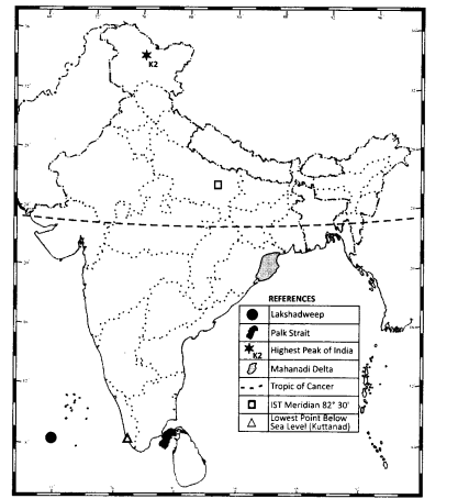
Locate on the political map of India:
(i) Highest peak, Palk Strait, Mahanadi Delta and Lowest point of India.
Answer:
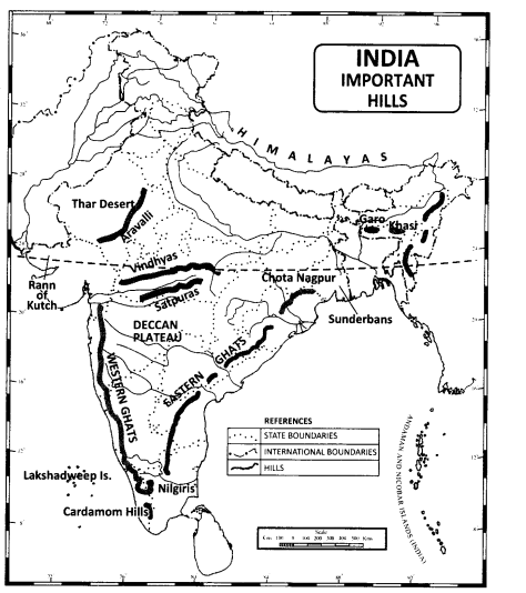
(ii) Important hills
Answer:
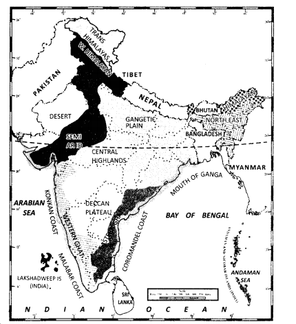
(iii) Coasts, Western and Eastern Ghats, Central Highlands, Desert, Island groups and Deccan plateaus.
Important hill stations
Answer:
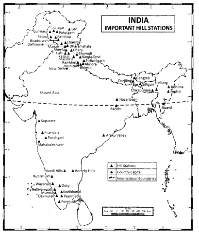
(iv)Important hill stations
Answer:
Question 2.
Locate different parts of the Himalayan mountains on a physical map of India.
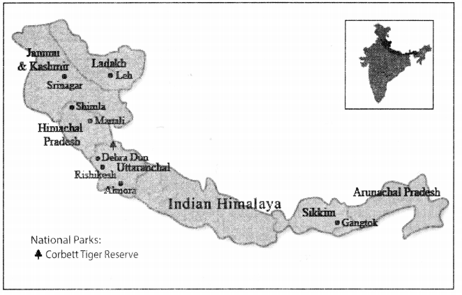
Answer:
