Class 11 Geography NCERT Solutions Chapter 1 India: Location
False______________________________________________________________________________________________________________
1. Choose the right answer from the four alternatives given below: 1. Choose the right answer from the four alternatives given below: 1. Choose the right answer from the four alternatives given below: 1. Choose the right answer from the four alternatives given below: 1. Choose the right answer from the four alternatives given below: 2. Choose the right answer from the four alternatives given below: 3. Choose the right answer from the four alternatives given below: 4. Choose the right answer from the four alternatives given below: 3. Choose the right answer from the four alternatives given below: 4. Choose the right answer
Question 1(i).
Which one of the following latitudinal extent is relevant for the extent of India’s area?
(a) 8°41’N – 35°7′ N
(b) 8°4’N – 37°6′ N
(c) 8°4’N – 35°6′ N
(d) 6°45’N – 37°6′ N.
Answer:
(b) 8°4’N – 37°6′ N
Question 1(ii).
Which one of the following countries shares the longest land frontier with India?
(a) Bangladesh
(b) China
(c) Pakistan
(d) Myanmar.
Answer:
(a) Bangladesh
Question 1(iii).
Which one of the following countries is larger in area than India?
(a) China
(b) Egypt
(c) France
(d) Iran.
Answer:
(a) China
Question 1(iv).
Which one of the following longitudes is the standard meridian for India?
(a) 69°30′ E
(b) 82°30′ E
(c) 75°30′ E
(d) 90°30′ E.
Answer:
(b) 82°30′ E.
True
Question 2(i).
Does India need to have more than one standard time? If yes, why do you think so?
Answer:
Yes, I think India needs to have more than one standard time.
- There is time variation of 2 hours between Easternmost and the Westernmost parts of our country. The sun rises two hours earlier in Arunachal Pradesh as compared to Gujarat.
- This is because the earth is tilted and also it rotates in east to west direction. So while rotation, the Eastern parts of the world experiences the sun rays earlier as compared to the western parts of the world.
- Many countries like USA, Canada and Russia have more than one standard time because their longitudinal extent is large. India’s longitudinal extent is also 30° approximately. Therefore, it is advisable to use more than one standard time.
Question 2(ii).
What are the implications of India having a long coastline?
Answer:
The total length of Coastline is 7,516.6 km.
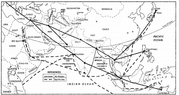
- India is a southward extension of the Asian continent. The trans Indian Ocean routes which connect the countries of Europe in the west and the countries of East Asia provide a strategic central location to India.
- The Deccan Peninsular protrudes into the Indian Ocean, thus helping India to establish close contact with west Asia, Africa and Europe from the Western coast and with Southeast Asia and East Asia from the Eastern coast.
- No other country has a long coastline on the Indian Ocean as India has and indeed, it is India’s eminent position in the Indian Ocean which justifies the naming of an Ocean after it.
Question 2(iii).
How is the latitudinal spread of India advantageous to her?
Answer:
There are three major advantages of latitudinal extent-
- Tropic of cancer (23 1/2°.) – It divides India into 2 parts. Southern part is in the tropical zone while northern part is in the temperate zone. Therefore biodiversity in India is exceptional.
- It also brings climatic diversity in India which has many advantages.
- As we move from Kannyakumari to Jammu and Kashmir duration of day and night decreases by more than 4 1/2 hours.
- We have places of all climates. It makes India a subcontinent.
Question 2(iv).
While the sun rises earlier in the east, say Nagaland and also sets earlier, how do the watches at Kohima and New Delhi show the same time?
Answer:
While the sun rises earlier in the east, say Nagaland and also sets earlier but the watches at Kohima and New Delhi show the same time because India follows one standard time all over its land. It is time shown at standard meridian of India. There is a general understanding among the countries of the world to select the Standard Meridian in multiples of 7° 30′ of longitude. Hence , 82°30′ E is chosen as the Standard Meridian of India and the time along the Standard Meridian of India passing through Mirzapur is taken as the Standard Time for the whole country.
Paraphrase: PROJECT/ACTIVITY/PROJECT/ACTIVITY/PROJECT/ACTIVITY/PROJECT/ACTIVITY/PROJECT/ACTIVITY/PROJECT/ACTIVITY/PROJECT/ACTIVITY/PROJECT/ACTIVITY/PROJECT/ACTIVITY/PROJECT/ACTIVITY/PROJECT/ACTIVITY/PROJECT/ACTIVITY/PROJECT/ACTIVITY/PROJECT/ACTIV
False
- On a graph paper, plot the number of districts in Madhya Pradesh, Karnataka, Meghalaya, Goa, Kerala, Haryana. Do the number of districts have some relationship with the area of the state?
- Which state amongst Uttar Pradesh, West Bengal, Gujarat, Arunacha! Pradesh, Tamil Nadu, Tripura, Rajasthan and Jammu and Kashmir is the most thickly populated and which one is the least densely populated?
- Find out the relationship between the area of the sate and the number of districts.
- Identify the states with coastal boundaries.
- Arrange the states from west to east which have only land boundary.
Answer:
Attempt yourself.
False
- List the Union Territories which have coastal location.
- How do you explain the variation in the area and population of NCT Delhi and the Andaman and Nicobar Islands?
- On a graph paper, draw a bar diagram to show the area and population of all the Union Territories.
Answer:
Attempt yourself.
Fake: Class 11 Geography Chapter 1 NCERT Extra Questions: Class 11 Geography Chapter 1 NCERT Extra Questions: Class 11 Geography Chapter 1 NCERT Extra Questions: Class 11 Geography Chapter 1 NCERT Extra Questions: Class 11 Geography Chapter 1 NCERT Extra Questions: Class 11 Geography Chapter 1 NCERT Extra Questions: Class 11 Geography Chapter 1 NCERT Extra Questions: Class 11 Geography Chapter 1 NCERT Extra Questions: Class 11 Geography Chapter 1 NCERT Extra Questions: Class 11 Geography Chapter 1 NCERT Extra Questions:
Falsifizieren Sie: Falsifizieren Sie: Falsifizieren Sie: Falsifizieren Sie: Falsifizieren Sie: Falsifizieren Sie: Falsifizieren Sie: Falsifizieren Sie: Falsifizieren Sie: Falsifizieren Sie: Falsifizieren Sie: Falsifizieren Sie: Falsifizieren Sie: Falsifizieren Sie: Falsifizieren
Question 1.
Which of the following country is not included in Indian subcontinent?
(a) Pakistan
(b) Nepal
(c) Bangladesh
(d) Maldives.
Answer:
(d) Maldives
Question 2.
What is India’s position from point of view of area?.
(a) Second
(b) Fifth
(c) Seventh
(d) Ninth.
Answer:
(c) Seventh
Question 3.
How much is the area of India?
(a) 328.7 million sq. Km
(b) 368.7 million sq. Km
(c) 288.5 million sq. Km
(d) 338.9 sq. Km.
Answer:
(a) 328.7 million sq. Km
Question 4.
How much is the longitudinal and latitudinal extent of India?
(a) 30 degree
(b) 45 degree
(c) 36 degree
(d) 40 degree.
Answer:
(a) 30 degree
Question 5.
What is the length of India from north to south? .
(a) 3214 km
(b) 2856 km
(c) 2933 km
(d) 2850 km.
Answer:
(a) 3214 km
Question 6.
What is the length of India from east to west?
(a) 3214 km
(b) 2856 km
(c) 2933 km
(d) 2850 km.
Answer:
(c) 2933 km
Question 7.
What is the percent share of India’s total area to world’s area?
(a) 4.5%
(b) 3.2%
(c) 2.4%
(d) 2.8%.
Answer:
(c) 2.4%
Question 8.
Himalayas in the north, Hindukush and Sulaiman ranges in the north-west, Purvachal hills in the north-east and by the large expanse of the Indian ocean in the south, it forms a great geographic entity which is called:
(a) Continent
(b) Subcontinent
(c) Indian Subcontinent
(d) Strait.
Answer:
(c) Indian Subcontinent
Question 9.
What separates India from Srilanka?
(a) Gulf of Mannar and Palk Strait.
(b) Bay of Hudson
(c) Bay of Bengal
(d) Bay of Biscay.
Answer:
(a) Gulf of Mannar and Palk Strait.
Question 10.
What is the length of the entire geographical coast of the mainland plus the island groups?
(a) 6204 km
(b) 6408 km
(c) 7517 km
(d) 6869 km.
Answer:
(c) 7517 km.
False
Question 1.
What do you mean by Indian subcontinent?
Answer:
Himalayas in the north, Hindukush and Sulaiman ranges in the north-west, Purvachal hills in the north-east and by the large expanse of the Indian ocean in the south forms a great geographic entity known as the Indian subcontinent.
Question 2.
Name the two southernmost neighbours of India.
Answer:
Maldives and Srilanka are the two southernmost neighbours of India.
Question 3.
Name the northernmost neighbour of India.
Answer:
China.
Question 4.
Name the easternmost neighbour of India
Answer:
Myanmar and Bangladesh.
Question 5.
Name the countries with which India shares its boundaries in the north-west?
Answer:
Pakistan and Afghanistan.
Question 6.
Name the countries with which India share its boundaries in the north-east?
Answer:
Nepal and Bhutan.
Question 7.
India and Srilanka are separated by what?
Answer:
Palk Strait and the Gulf of Mannar.
Question 8.
Which countries are included in Indian subcontinent?
Answer:
It includes the countries — Pakistan, Nepal, Bhutan, Bangladesh and India.
Question 9.
What is the length of landmass of India?
Answer:
15200 km.
Question 10.
What is the length of international border between India and Pakistan?
Answer:
3310 km.
Question 11.
Name the southernmost part of India.
Answer:
Indira Point.
False______________________________________________________________________________________________________________
Question 1.
Why is there a time variation of 2 hours between the easternmost and westernmost part of the country?
Answer:
Longitudinal extent of India is 68°7′ to 97°25′ E-(2-9°). There is time variation of 2 hours between easternmost and the westernmost parts of our country. The sun rises two hours earlier in Arunachal Pradesh as compared to Gujarat. This is because the earth is tilted and also it rotates in east to west direction. So while rotation, the eastern parts of the world experiences the sun rays earlier as compared to the western parts of the world.
1 degree = 4 minutes
30 degree = 4 x 30 = 120 minutes
120 minutes = 2 hours
Question 2.
What is the size of India with reference to the World? Name the countries larger in area than India? Explain the location of India on the globe?
Answer:
The size of India is 3.28 million square km which accounts for 2.6% of the total land of the world. India is the seventh largest country in the world. The following countries are larger in area.than India: Russia, China, Canada, Brazil and Australia.
- India lies entirely in the Northern hemisphere. The mainland extends (Kanniyakumari, Cape Caverian) and 37°6′ N (Indira col, Jammu and Kashmir) and longitudes 68°7′ E (Dwarka, Gujarat) and 97°25′ E (Sadiya, Arunachal Pradesh).
- India’s territorial limit extends towards the sea upto 12 nautical miles ( about 21.9km) from the coast.
Question 3.
Explain in detail about the neighbouring countries of India.
Answer:
India is bounded by the Himalayas in the north, Hindukush and Sulaiman ranges in the north- west, Purvachal hills in the north-east and by the large expanse of the Indian ocean in the south, it forms a great geographic entity known as the Indian subcontinent. It includes the countries — Pakistan, Nepal, Bhutan. Bangladesh and India. India is located in the south-central part of the continent of Asia, bordering the Indian ocean and its two arms extending in the form of Bay of Bengal and the Arabian Sea, This maritime location of Peninsular India has provided links to its neighbouring regions through the sea and air routes. Sri Lanka and Maldives are the two island countries located in the Indian Ocean, which are our neighbours. Sri Lanka is separated from India by the Gulf of Mannar and Palk Strait.
Question 4.
What is a Gulf?
Answer:
A gulf can be described as a large body of water that is almost encircled by land except for a small mouth that is opened out to the ocean. While it can be described as a large bay, the Gulf of Mexico is considered to be the largest in the world consisting of a total surface area of about 1,554,000 square kilometres. It is surrounded by the southern coast of the United States, Mexico and Cuba while also being comprised of several bays such as the Mobile Bay in Alabama and the Matagorda Bay in Texas. With typically less windy environment than open areas of the coast, gulfs have proved themselves as valuable town areas as they provide easy access to the sea while being protected as well.
Question 5.
What is a Strait?
Answer:
A strait can be defined as a naturally formed narrow strip of water between two continents, islands or two larger bodies of water. It is usually used for navigational purposes and is sometimes referred to as a channel when it is found between two land masses. Firth is another term often used to refer to straits, although sometimes varying in definition according to the context and the nature of the strait. Straits have served as a crucial part for shipping routes and wars have been fought over the control of straits due to their paramount importance. The strait of Gibraltar that separates northern Africa from the Rock of Gibraltar on the southernmost point of the Iberian Peninsula is perhaps the world’s most famous strait as this is the shipping route that was most utilized for all commercial purposes between the Mediterranean Sea and the Atlantic Ocean.
Question 6.
What is a Bay?
Answer:
A bay is formed when the water from an ocean or a sea stops because of land mass. There is a small inlet passage before the water body becomes large, and then it gets surrounded by land on three sides, to be called a bay, depending upon the people who name it accordingly. Mostly these water bodies have been named as bays depending upon the perception of the people viewing it. If they think they are small, then the smaller ones have been called bays.
False
Question 1.
Size of India has endowed India with unique physical diversity. Substantiate.
Answer:
The size of India has endowed her with great physical diversity. The presence of lofty mountains in the north; large rivers such as Ganga, Brahmaputra, Mahanadi, Krishna, Godavari and Kaveri; green forested hills in the north-east and south India; and the vast sandy expanse of Marusthali is very impressive. It is bounded by the Himalayas in the north, Hindukush and Sulaiman ranges in the north-west, Purvachal hills in the north-east and by the large expanse of the Indian ocean in the south. The Himalayas, together with other ranges, have acted as a formidable physical barrier in the past. Except for a few mountain passes such as the Khyber, the Bolan, the Shipkila, the Nathula, the Bomdila, etc. it was difficult to cross it.
True
Question 2.
Explain in detail about size and extension of India.
Answer:
Total area of India republic is 32,87,263 sq. Km. From the point of view of area, India is seventh largest country of the world. Its population is 1210 million and it has second position in the world after china from population point of view. The mainland of India, extends from Kashmir in the north to Kanniyakumari in the south and Arunachal Pradesh in the east to Gujarat in the west. India extends from territorial limit further extends towards the sea upto 12 nautical miles (about 21.9 km) from the coast. India lies entirely in the Northern hemisphere. The mainland extends between latitudes 8 4′ N (Kanniyakumari, Cape Caverian) and 37 6′ N ( Indira col, Jammu and Kashmir) and longitudes 68 7′ E (Dwarka, Gujarat) and 97 25′ E (Sadiya, Arunachal Pradesh).
True
Question 3.
Differentiate the following:
(a) Gulf and Strait
(b) Gulf and Bay
Answer:
gulf and strait are two terms that are often discussed when it comes to geography . straits and gulfs are both common features in seafaring . each feature has its own unique characteristics which in turn give them a unique purpose in the history of mankind .
- Meaning: A gulf is a large body of water almost encircled by land except for a small mouth that opens out to the sea. A strait is a strip of water that separates two lands or two large bodies of water.
- Use: Straits are used for navigational purposes and have played an integral part when it comes to shipping routes. Gulfs are more useful for human settlements, as such areas provide easy access to the ocean while being well protected as well.
- Association: Gulfs can be easily associated with inland bodies of water as well as the ocean. Straits are mostly discussed with regards to the ocean.
(b) Difference between Gulf and Bay (b) Difference between Gulf and Bay (c) Difference between Gulf and Bay (d) Difference between Gulf and Bay (e) Difference between Gulf and Bay (e) Difference between Gulf and Bay (e) Difference between Gulf and Bay (e) Difference between Gulf and Bay (e) Difference between Gulf and Bay (e) Difference between Gulf and Bay (e) Difference between Gulf and Bay (e) Difference between Gulf and Bay (e) Difference between Gulf and Bay (e) Difference between Gulf and Bay (
- A bay is not as enclosed by land masses as a gulf.
- Gulf is formed because of erosion of the rocks as water makes inroads into adjoining land.
- Gulfs take any form while bays are mostly oval or round shaped.
False
Question 1.
Explain in detail the implications of latitudinal extent of India?
Answer:
There are three major implications of latitudinal extent-
- Tropic of cancer (231/2 .) – It divides India into 2 parts.
- The places above Tropic of Cancer are Northern India and below Tropic of Cancer is Southern India.
- Well connected to east/west of the world the total area of India is 3.8 million sq km of total land.
- As we move from Kanniyakumari to Jammu/Kashmir duration of day and night decreases by more than 4V2 hours.
- This is because of unequal duration of latitude by Circle of Illumination.
Question 2.
Explain the implications of longitudinal extent of India?
Answer:
Longitudinal extent of India 68 7’to 97 25′ E -(29 )
Implications:
- Well connected to the parts of Eastern and Western parts of the world.
- 821/2 E is choose as standard Meridian of India.
- Greenwich Mean Time (GMT) – India is 51/2 hours ahead of the Greenwich Mean Time and 821/2 E is choosen as the Standard Meridian of India.
- Due to the longitudinal extent there is a time long of 2hours. Between Eastern and Western parts of India. The sun rises 2 hours earlier in Arunachal Pradesh as compared to Gujarat.
Question 3.
Why 82 30′ E is chosen as the Standard Meridian of our country?
Answer:
There is a general understanding among the countries of the world to select the Standard Meridian in multiples of 7 30′ of longitude. Hence, 82 30′ E is chosen as the Standard Meridian of India and the time along the Standard Meridian of India passing through Mirzapur is taken as the Standard Time for the whole country.
Question 4.
What are the implications of India having along coastline?
Answer:
The total length of Coastline is 7,516.6 km.
-
India is a southward extension of the Asian continent. The trans Indian Ocean
routes which connect the countries of Europe in the west and the countries of East Asia provide a strategic central location to India. -
The Deccan Peninsular protrudes into the Indian Ocean, thus helping India to establish close contact with west Asia, Africa and Europe from the Western
coast and with Southeast Asia and East Asia from the Eastern coast. - No other country has a long coastline on the Indian Ocean as India has and indeed, it is India’s eminent position in the Indian Ocean which justifies the naming of an Ocean after it.
Map Skills
Question 1.
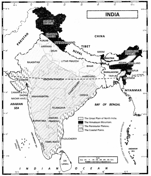
By referring to the physical map of India describe the physical variations which you would come across while travelling from Kashmir to Kanniyakumari and from Jaisalmer in Rajasthan to Impbal in Manipur
Answer:
While travelling from Kashmir to Kanniyakumari and from Jaisalmer in Rajasthan to Imphal in Manipur, we shall come across varied physical features of India. It is shown in the map given below:

Question 2.
Exhibit the location of India in the Eastern World, Ans.
Answer:

Question 3.
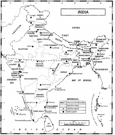
Locate the states which share borders with:
(a) Pakistan
Answer:
Pakistan – Gujarat, Rajasthan, Punjab, Jammu and Kashmir.
(b) China
Answer:
China – Jammu and Kashmir, Himachal Pradesh, Uttaranchal, Sikkim, Arunachal Pradesh.
(c) Bhutan
Answer:
Bhutan – Sikkim. Assam, Meghalaya, Tripura.
(d) Bangladesh
Answer:
Bangladesh – West Bengal, Assam, Meghalaya, Tripura
(e) Myanmar
Answer:
Myanmar – Nagaland, Manipur, Mizoram. Arunachal Pradesh.
(f) Nepal
Answer:
Nepal – Uttarakhand, Uttar Pradesh, Bihar, West Bengal, Sikkim

Question 4.
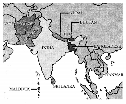
On a political map of India locate:
(a) The two southernmost neigh¬bours of India.
Answer:
Maldives and Srilanka are the two southernmost neighbours of India.
(b) The northernmost neighbour of India.
Answer:
China.
(c) The easternmost neighbour of India.
Answer:
Myanmar and Bangladesh.
(d) The countries with which India shares its boundaries in the northwest?
Answer:
Pakistan and Afghanistan.
(e) The countries with which India share its boundaries in the northeast?
Answer:
Nepal and Bhutan
