CBSE Previous Year Question Papers Class 12 Geography 2013 Outside Delhi
Time allowed : 3 hours
Maximum marks: 70
True
- There are 22 questions in all.
- All questions are compulsory.
- Question number 1 to 7 are very short-answer questions carrying 1 mark each. Answer to each of these questions should not exceed 40
- Question numbers 8 to 13 are short-answer questions carrying 3 marks each. Answer to each of these questions should not exceed 80-100 words.
- Question numbers 14 to 20 are long-answer questions carrying 5 marks each. Answer to each of these questions should not exceed 150
- Question numbers 21 to 22 are related to identification or locating and labelling of geographical features on maps, carrying 5 marks each.
- Outline maps of the World and India provided to you must be attached within your answer-book.
- Use of templates or stencils for drawing outline maps is allowed.
False
True
Question 1.
Name the most densely populated region in North America. [1]
Answer:
North-East USA.
Question 2.
Give the meaning of Age-sex structure of population. [1]
Answer:
The Age Sex structure of population generally deals with the number of male and female of different age groups.
Question 3.
Which highway connects north America to south America ? [1]
Answer:
Pan-American Highway.
Question 4.
What are naval ports ? Give one example of naval port. [1]
Answer:
Naval ports are those which have only strategic importance. These ports serve worships and have repair workshops for them.
Example-Kochi, Karwar.
Question 5.
Define the term ‘tertiary activities’. [1]
Answer:
The tertiary activities involve the provision of services to other business as well as final consumers. Services may involve the transport, distribution and sale of goods from producer to a consumer, as may happen in wholesaling and retailing, or may involve the provision of a service, such as in pest control or entertainment.
Question 6.
Give any two examples of ‘quaternary activities’. [1]
Answer:
- Collection of information.
- Production of information.
Question 7.
Give the meaning of ‘clustered rural settlement’ in India. [1]
Answer:
The clustered rural settlement is the kind of settlement that generally develops in the fertile plain and river valleys. The density of population in such areas is very high because of high productivity of the land.
Question 8.
State the main functions of ‘Border Roads Organization’ (BRO). [1]
Answer:
The main functions of BRO are :
-
In peace
- To develop and maintain the operational road infrastructure of general staff in the border areas.
- To contribute to the socio-economic development of the border states.
-
In War
- To develop and maintain roads to keep line of control through in original sectors and re-deployed sectors.
- To execute additional tasks as laid down by the government contributing to the war effort.
Question 9.
Name the major seaport located on Hooghly River. [1]
Answer:
Kolkata port.
Question 10.
Mention any two sources of land pollution in India. [1]
Answer:
The sources of land pollution in India are :
- Untreated industrial wastes.
- Excessive use of pesticides and fertilizers.
Question 11.
Define ‘Human Geography’ in your own words. Mention any four fields of human geography. [3]
Answer:
Human geography is the study of the many cultural aspects found throughout the world and how they relate to the spaces and places where they originate and then travel as people continually move across various areas.
Some of the main cultural phenomena studied in human geography include language, religion, different economic and governmental structures, art, music, and other cultural aspects that explain how and/or why people function as they do in the areas in which they live. Globalization is also becoming increasingly important to the field of human geography as it is following these specific aspects of culture to easily travel across the globe.
Fields:
- Social geography,
- Urban geography
- Political geography,
- Population geography,
- Settlement geography,
- Economic geography.
Question 12.
Describe three main sources of noise pollution in India. [3]
Answer:
- Industries and factories.
- Mechanized construction works.
- Automobiles.
Question 13.
Describe any three advantages of water transport in the world. [3]
Answer:
- It does not require the construction of routes because it is naturally built. Requirement of construction is nominal in comparison to other sources of transportation.
- Entire world is linked up with this medium.
- The cost of transportation is lower in comparison to other modes.
Question 14.
Explain any three characteristics of modern large scale manufacturing in the world. [3]
Answer:
- Mechanization.
- Specialization of different skills.
- Innovation in technology.
- Organizational structure and stratification.
- Uneven Geographic Distribution.
Question 15.
Explain any three characteristics each of hamleted and dispersed rural settlement in India. [3]
Answer:
Hamleted Rural Settlement:
- Houses are clustered or compacted and congested.
- Poor sanitation and ventilation.
- Houses are close to each other and streets are very narrow.
- These units are locally called Panna, Para, Nagla, Dhani, etc., in various parts of the country.
- It appears in India in the form of isolated huts or hamlets.
- Safety of these households is threatened because of isolation.
- Households have to travel a long distance for basic commodities.
- Many areas of Meghalaya, Uttaranchal, Himachal Pradesh and Kerala have this type of settlement.
Question 16.
Explain any three features of ‘dry land farming’ in India. [3]
Answer:
Dry and farming: It refers to an ingrained system of cultivation where by maximum amount of water is conserved by soil and water management.
False
- It is mainly practised in areas with uncertain or limited annual rainfall.
- Prevalence of more cropping.
- Mostly similar crops are grown by almost all the farmers of a particular region.
Question 17.
Examine any three causes for the deterioration of ‘quality of water’ in India. [3]
Answer:
- Wastes caused by urbanization and industrialization.
- Excessive use of pesticides in farming.
- Rivers receive millions of liters of sewage, mining, industrial wastes.
Question 18.
Give two advantages of ‘wind energy’. Mention four states of India having favourable conditions for the development of wind energy. [3]
Answer:
The advantages of wind energy are :
- The wind is free and with modern technology it can be captured efficiently.
- Once the wind turbine is built the energy it produces does not cause greenhouse gases or other pollutants.
- Although wind turbines can be very tall each takes up only a small plot of land.
True
entailment
- Rajasthan
- Gujarat
- Maharashtra and Karnataka.
Question 19.
Analyse any three locational factors which helped in the development of ‘Hooghly Industrial Region’. [3]
Answer:
- Development of river ports in Hooghly River.
- Mega city located near by Hooghly river is Kolkata that is well connected with other sources of transportation.
- Availability of cheap labour from West-Bengal and Bihar regions.
Question 20.
“Equity is one of the most important pillars of human development.” Explain any three human values that are required to give equal access to opportunities to everybody. ** [3]
Question 21.
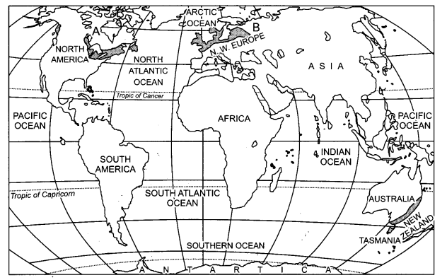
Study the given map, showing dairy farming regions, carefully and answer the following questions :
Question 21.1.
Identify and name the areas A and B, marked on the map. [5]
Answer:
A-Canada & North-east USA. B-North-western Europe
Question 21.2.
Define ‘dairy farming’.
Answer:
Dairy farming is described as a class of animal or agricultural husbandry that deals with milk production from dairy cows, sheep and goats. The milk may be transported to a dairy factory or be processed on site.
Question 21.3.
Explain any three characteristics of dairy farming.
Answer:
- It is most advanced type of farming for rearing milk animals.
- It is highly labour intensive farming.
- It is practiced near urban areas.
Question 22.
Explain the two types of international trade. Examine any three possible negative impacts of globalization along with free trade in the world. [5]
Answer:
Two types of international trade are :
- Bilateral Trade : This type of trade is done by two countries with each other. They enter into agreement to trade specified commodites amongst them.
- Multilateral Trade : This type of trade is conducted with many countries. The same country can trade with a number of other countries. The country may also grant the status of the ‘Most Favoured Nation’ (MFN) on some of the trading partners.
Negative impact of globalization :
- Local producers are not able to compete with the foreign market products because they provide some kind of products at cheaper rates.
- Uncertainty of employment has increased cultural invasion.
- Countries also need to be cautious about dumped goods, as long with free trade dumped goods of cheaper price can harm the domestic producers.
Question 23.
Explain any five factors that affect the location of rural settlements of the world. [5]
Answer:
The factors that affect the location of rural settlements of the World are:
(i) Water Supply : Usually rural settlements are located near water bodies such as rivers, lakes and springs where water can be easily obtained. The need for water drives people to settle in islands surrounded by swamps or low lying riverbanks. Water supply is main factor because water is used for drinking, cooking and washing, rivers and lakes can be used to irrigate farm land, water bodies also have fish which can be caught for diet and navigable rivers and lakes can be used for transportation.
True
(iii) Upland: Villages are located on uplands, which is not prone to flooding. Thus, in low-lying river basins people chose to settle on terraces and levees, which are “dry points”.
In tropical countries people build their houses on stilts near marshy lands to protect themselves from flood, insects and animal pests.
True
False
Question 24.
Examine any five push factors that cause ‘migration of population’ in India. [5]
Answer:
- Large number of young people are migrating because rural India is saturated and cannot provide employment opportunities for a growing population.
- Most women migrants have migrated after marriage. In North India, women are not supposed to marry a man from the same village. So invariably marriage means migration. ,
- Many end up as rag pickers or casual construction workers. Many don’t get employment throughout the year and commute between urban and rural areas. After the harvest, they migrate to urban areas for a few months before the rainy season.
- Intolerance towards a certain class, sector cultural group also causes migration.
- Natural disasters or epidemics are also causes of migration because it causes outbreaks of diseases which may be life-threatening.
Question 25.
What are National Highways ? Explain any four uses of National Highways in India. [5]
Answer:
The National Highways are a network of highways that is managed and maintained by agencies of the Government of India. These highways measured over 70,934 km as of 2010, including over 1,000 km of limited- access Expressways.
Uses of National Highways :
- It works as mega source of transportation. National highways constituted about 2% of all the roads in India, but carried about 40% of the total traffic of 2010.
- National highways form the economic backbone of the country and have often facilitated development along their routes, and many new towns have sprung up along major highways.
- It connects almost all mega cities. Basically these are meant for inter-state transport.
- It is connected to or passes nearby the industries so that their products can reach out to market easily.
Question 26.
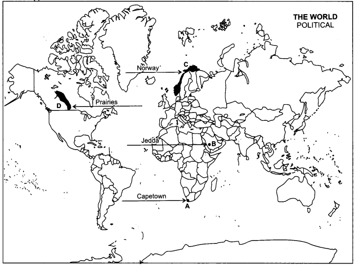
(i) In the given political outline map of the world, four features have been marked as A, B, C and D. Identify these features with the help of following information and write their correct names on the lines drawn near them. [5]
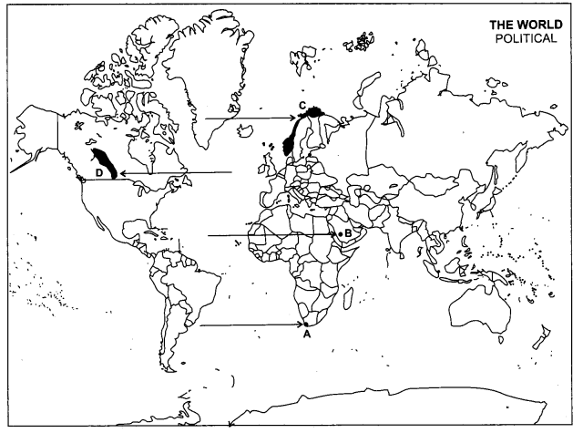
(A) A major sea port Human Development Index.
(B) A major airport
(C) The country having highest rank in farming.
(D) An area of extensive commercial grain
Answer:
(ii) Locate and label the following on the political outline map of India with appropriate symbols.
(a) A state having highest literacy rate. Zone.
(b) A copper mining area of southern Jharkhand,
(c) Headquarter of North-Western Railway
(ii)
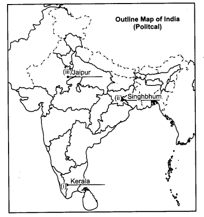
True
False
Question 2.
What is the difference between the Growth and Development ? [1]
Answer:
Growth is a narrower concept than development. Development is an increase in a country’s real level of national output which can be caused by an increase in the quality of resources (by education etc.), increase .in the quality1-of resources and improvements in technology or in another way an increase in the value of goods and’services produced by every sector of the economy.
Question 5.
Give the meaning of Retail trading services. [1]
Answer:
Retail trading services are kind of business engaged in offering goods and services directly to • consumers. In most cases, retail outlets are primarily concerned with selling merchandise.
Question 8.
State the main functions of ‘National Highway Authority of India’ (NHAI). [1]
Answer:
Main functions of NHAI are :
- Development of National Highways across India.
- Maintain the National Highways and ensure the safety.
Question 9.
How has the Gaddi Tribal community of Bharmaur region maintained a distinct identity ? [1]
Answer:
- They practiced transhumance in the Himalayan Region.
- They conserved their culture through Gaddian dialect.
Question 13.
What is free trade ? Give two advantages of free trade. [3]
Answer:
Free trade is a policy in international markets in which governments do not restrict imports or exports. Free trade is exemplified by the European Union/European Economic Area and the North American Free Trade Agreement, which have established open markets. Most nations are today members of the World Trade Organization (WTO) multilateral trade agreements.
Advantages :
- Goods and services can reach to everywhere.
- Foreign goods can compete with domestic goods.
Question 14.
Give the meaning of high-tech industry. State any two characteristics of this industry. [3]
Answer:
The term high-tech refers to technology that is at the cutting edge : the most advanced technology available. It is often used in reference to microelectronics, rather than other technologies. This sector contains business revolving around the manufacturing of electronics, creation of software, computers or products and services relating to information technology.
False
- Professional workers make a large share to its workforce.
- These industries are neatly spread, low, modern, dispersed, office plant lab building rather than massive structures.
Question 16.
Describe any three characteristics of Svetland farming’ in India. [3]
Answer:
The characteristics of wetland farming in India:
- The rainfall is excessive of soil moisture requirements.
- These regions often face flood or soil erosion hazards.
- Water intensive crops are grown like-paddy, jute etc.
Question 19.
Explain any three locational factors which helped in the development of ‘Gujarat Industrial Region’. [3]
Answer:
Location factors which helped in the development of Gujarat Industrial Region are :
- Gujarat is basically known for cotton industries. Raw material for this industry is easily available here.
- Market for industries are nearby cities like – Ahmedabad, Surat, Vadodara etc.
- The discovery of oil fields led the establishment of petrochemical industries around Ankleshwar, Jamnagar and Vadodara.
- Anand has developed as biggest dairy products producing city in India.
Question 23.
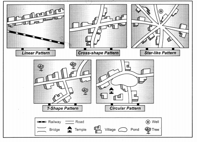
Explain any five patterns of rural settlements in the world with the help of suitable diagrams. [5]
Answer:
On the basis of forms of shapes, the 5 patterns of rural settlements in the world are :
-
Linear Pattern:
- These type of setdements have two parallel rows of houses facing each other.
- In such setdements, houses are located along a road, railway line, river or a canal edge.
- These type of setdements are common in coastal Kerala, Manipur, Bala Ghat, Mandala and Raigrah districts of Madhya Pradesh and Chhattisgarh.
- Linear setdements are also common feature of Nagaland.
- Fishing villages in the coastal areas also look like linear cluster.
-
Rectangular Pattern :
- Such villages develop at the meeting place of two roads.
- The streets are either parallel or perpendicular to each other and the settlement takes a rectangular shape.
- These type of settlements are more common in the Northern plain especially in the Ganga-Yamuna Doab.
- These settlements are also found in Tamil Nadu, Karnataka, Andhra Pradesh and the states of South India.
-
Circular Pattern :
- When the houses are constructed along a bank of a pond or a lake, the settlement takes the shape of circle and is known as circular pattern.
-
These type of settlements are mainly found
in Upper Ganga-Yamuna Doab, Trans-Yamuna region and in parts of Madhya Pradesh, Gujarat and Maharashtra.
-
Star-like Pattern :
- A village acquires a star-like pattern when streets radiate from a common centre.
- Expansion of these villages due to population growth leads to the formation of a double radial pattern. In this pattern, several roads converge star shaped settlements developed by houses built along the roads.
- This type of pattern is more common in Tamil Nadu and Upper Ganga Plain.
- T-shaped Pattern : Villages and towns confined between two rivers at their junction or confluence or between bifurcations of two roads eventually result in a T-shape pattern. Such pattern develops at tri-junction of roads.
