CBSE Previous Year Question Papers Class 12 Geography 2013 Delhi
Time allowed : 3 hours
Maximum marks: 70
True
- There are 22 questions in all.
- All questions are compulsory.
- Question number 1 to 7 are very short-answer questions carrying 1 mark each. Answer to each of these questions should not exceed 40
- Question numbers 8 to 13 are short-answer questions carrying 3 marks each. Answer to each of these questions should not exceed 80-100 words.
- Question numbers 14 to 20 are long-answer questions carrying 5 marks each. Answer to each of these questions should not exceed 150
- Question numbers 21 to 22 are related to identification or locating and labelling of geographical features on maps, carrying 5 marks each.
- Outline maps of the World and India provided to you must be attached within your answer-book.
- Use of templates or stencils for drawing outline maps is allowed.
False
True
Geography 2013 (Delhi)
Time allowed : 3 hours
Question 1.
Give the meaning of ‘Crude Birth Rate’ (CBR). [1]
Answer:
The crude birth rate is the number of live births per 1,000 people per year. We can calculate CBR by the following formula :
CBR = Bi/P multiplied by 100 where Bi denotes live births during the year.
P is the mid year population of the area.
Question 2.
How is sex ratio calculated in different countries of the world ? [1]
Answer:
Sex ratio is calculated by the following formulas :

OR
(iii) The number of females per thousand males
Question 3.
State and two functions of World Trade Organization (W.T.O.). [1]
Answer:
- It overseas the implementation, administration and operation of the covered agreements.
- And it provides a forum for negotiations and for settling disputes.
Question 4.
Which State of India has the lowest female literacy rate ? [1]
Answer:
Bihar.
Question 5.
Mention any two causes of the negative growth rate of population in India during 1911-1921. [1]
Answer:
- Poor health facilities and
- Lack of basic necessities.
Question 6.
Give any two examples of mining towns in India. [1]
Answer:
- Jharia
- Digboi.
Question 7.
What is ‘sectoral planning’ ? [1]
Answer:
The Sector Plan provides general guidelines directed towards ensuring the orderly and efficient development of a plan area. The sector plan addresses essential services and facilitates, land uses, transportation systems, population density and sequencing of development. Full consideration must be given to the costs and benefits of various actions upon the present and future social, economic and environmental fabric of the area.
Question 8.
Why is the density of rural roads very low in the hilly areas of India ? Give one reason. [1]
Answer:
- Nature of difficult terrain,
- Poor economic condition in those areas.
Question 9.
Give the meaning of the term ‘Hinterland’. [1]
Answer:
The hinterland is the land or district behind a coast or the shoreline of a river. It is the rural outlying region that supports a town or city with agricultural products and raw materials. The hinterland ships fresh fruits, vegetables, and milk into the city to provide the village with the finest fresh products.
Question 10.
Mention any two sources of water pollution in India. [1]
Answer:
- Toxic effluents from industries.
- Sewage disposal in rivers without detoxification.
Question 11.
Explain the concept of ‘Possibilism’, with three, suitable examples. [3]
Answer:
Possiblism is a view of the environment as a range of opportunities from which the individual may choose. This choice is based on the individual’s needs and norms. It grants that the range of choices may be limited by the environment, but allows choices to be made, rather than thinking on deterministic lines.
Exemples : a paraphrased version of the phrase '''''''''''''''''''''''''''''''''''''''''''''''''''''''''''''''''''''''''''''''''''''''''''''''''
- Health resorts of highlands
- Orchards
- Ports on the costs
- Satellites in the space.
Question 12.
Analyze any three major problems of slum dwellers in India. [3]
Answer:
- Poor sanitation
- Poor ventilation
- Lack of basic amenities
- They are low paid workers.
- Their areas are overcrowded having narrow street pattern prone to serious hazard from fire.
Question 13.
Explain any three points of economic significance of ‘Trans-Siberian Railway’. [3]
Answer:
- It is the most significant route in Asia.
- It helps to connect Asian market with West European market.
- It is the longest double tracked electric railway in the world.
Question 14.
What is cyber space ? Describe any two advantages of internet. [3]
Answer:
The word “cyberspace” is credited to William Gibson, who used it in his book, Neuromancer, written in 1984. Cyberspace is the notional environment in which communication over computer networks occurs. As a social experience, individuals can interact, exchange ideas, share information, provide social support, conduct business, direct actions, create artistic media, play games, engage in political discussion, and so on, using this global network.
Few advantages are :
- Anyone can share ideas, view from any part of the world.
- The concept of Global village becomes truth with its help.
- It is significant in terms of education and entertainment. In fact it creates the environment for Edutainment.
Question 15.
Explain with example, how ‘stage of economic development’ and ‘foreign investment’ become the basis of international trade. [3]
Answer:
Stage of Economic Development :
The nature of items traded undergoes changes as the different stages of economic development of countries passes. In agro-based countries, agro products are exchanged for manufactured goods where as industrialized nations export machinery and finished products and import food grains and other raw materials. The study of economic development mainly focused entirely on national product, or the aggregate output of goods and services.
True
Question 16.
Explain any three push factors that have caused rural to urban migration in India. [3]
Answer:
- In India, people migrate from villages to towns/cities due to poor economic conditions at village.
- Lack of basic amenities like-education, healthcare etc.
- Lack of infrastructure like-roads, water, electricity etc.
Question 17.
What are hamleted settlements ? Mention any two areas of India where such settlements are found. [3]
Answer:
A hamlet is a settlement, which is too small to be considered a town or village. As a general rule, hamlets are rural, and many of them arise around a specific site such as a mill or a large farm. In some countries, hamlets are legally defined, while in others; the world is simply a term to describe a small settlement, with no firm definition attached.
False
- Middle and lower parts of the Ganga plain
- Lower valleys of the Himalayas.
- Chhattisgarh.
Question 18.
Give two advantages of ‘copper’. Mention four main copper mining areas of India. [3]
Answer:
- Copper and the copper alloys are some of the most versatile materials available and are used for applications in every type of industry.
- Besides good conductivity the properties include strength, hardness, ductility, and resistance to corrosion, wear and shock, low magnetic permeability, an attractive range of colors together with ease of machining, forming, polishing and plating.
Copper mining areas in India are : : : ; ; ; ; ; ; ; ; ; ; ; ; ; ; ; ; ; ; ; ; ; ; ; ; ; ; ; ; ; ; ; ; ; ; ; ; ; ; ; ; ; ; ; ; ; ; ; ; ; ;
-
- Khetri
- Balaghat
- Singhbhum
- Jhunjhunu.
Question 19.
Explain the role of ‘power’ and ‘raw-material’ in the location of heavy industries in India. [3]
Answer:
Energy crisis has a great bearing on the industrial development and production. Although the installed capacity of electricity increased from 66.08 million km in 1990-91 to 85.79 million km in 1996-97 but it is much short of the actual demand. It leads to power cut and rostering, which hampers the industrial production. Most of the state electricity boards are running in loss and are in deplorable condition. Rail transport is overburdened while road transport is plagued with many problems. Even national highways in many places are in bad shape.
True
natural calamities like drought, famine, flood etc., badly affect agricultural production . failure of monsoon even affects the purchasing power of the people . it sometimes creates glut in the market and industrial plumpness .
Question 20.
Explain any three human values which are required to empower socially and economically disadvantaged people. *[3]
Question 21.
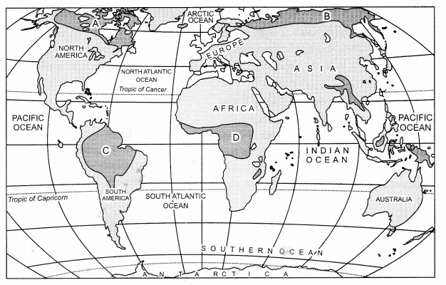
Study the given map, showing areas of subsistence gathering carefully and answer the following questions: [5]
(i) Identify and name the areas marked A, B, C and D in your answer-book.
(ii) Explain any four characteristics of gathering.
(iii) Why can’t gathering become important at the global level ? Give two reasons.

Answer:
(i) A-North Canada
B-Amazon Basin
C-Northern Eurasia
D-Tropical Africa
(i) (ii) (iii) (iv) (v) (v) (v) (iv) (v) (iv) (iv) (v) (iv) (v) (iv) (v) (iv) (v) (iv) (v) (v) (v) (v) (v) (v) (v) (v) (v) (v) (v) (v) (v) (v) (v)
- Gathering is practiced in the regions having harsh climate conditions.
- It involves primitive societies, which depends on wild animals and plants.
- This type of activity requires a small amount of capital investment.
- The yield per person is very low and they hardly have any surplus.
(iii)
- Modern gatherers have had no opportunity to move into new territories.
- Products of such types of activity cannot compete in the world market.
Question 22.
Define ‘manufacturing’. Classify manufacturing industries on the basis of size into three categories. Explain an important characteristic of each category. [5]
Answer:
Manufacturing is the production of merchandise for use or sale using labour and machines, tools, chemical and biological processing, or formulation. The term may refer to a range of human activities, from handicraft to high tech, but is most commonly applied to industrial production, in which raw materials are transformed into finished goods on a large scale. Such finished goods may be used for manufacturing other more complex products, such as aircraft, household appliances or automobiles.
True
- Cottage or household industries.
- Small-scale industries.
- Large-scale industries.
True
Question 23.
Classify urban settlements on the basis of size, functions and services available into five categories and explain an important characteristic of each type. [5]
Answer:
Depending on the size, functions and the service available, urban settlements are designated as town city, million city, conurbation, and megalopolis.
- Town : Population size in town is higher than the village. Functions such as, manufacturing, retail and wholesale trade, and professional services exist in towns.
- City : A city may be regarded as a leading town. Cities are much larger than towns and have a greater number of economic functions. They tend to have transport terminals, major financial institutions and regional administrative offices. When the population crosses the one million mark it is designated as a million city.
- Million City : The cities having more than million population is known as million city. The number of these types of cities in the world have been increasing as never before.
- Conurbation : The term conurbation was coined by Patrick Geddes in 1915 and applied to a large area of urban development resulted from the merging of originally separate towns or cities. Greater London, Greater Mumbai, Manchester, Chicago and Tokyo are examples.
- Megalopolis : This Greek word meaning “great city”, was popularized by Jean Gottman (1957) and signifies ‘super-metropolitan’ region extending union of conurbations. The urban landscape stretching from Boston in the north to south of Washington in U.S.A. is the best-known example of a megalopolis.
Question 24.
Explain any three factors responsible for the depletion of water resources. Examine any two legislative measures for controlling water pollution in India. [5]
Answer:
(i) Increased use of irrigation : The impact of increased use of water for irrigation is a decrease in the quality and quantity of downstream water, with, implications on both ecosystem functioning and on downstream use for agriculture, industry and municipal supplies. However, as the demand area, the farmland, is often distant from the critical urban/industrial demand areas, these linkages are often overlooked.
discharged wastewater is generally loaded with nutrients (N and P) and organic compounds . when discharged directly onto surface water, the large quantities of wastewater easily exceed the natural cleaning capacity of the system .
False
- The government of India has enacted a number of pieces of legislation, such as the Water (Prevention and Control of Pollution) Act, 1974 and amended in 1998.
- Environment Protection Act, 1986, a system of environmental audit introduced to enable the production units to evaluate the raw materials, utilities, and operational efficiencies to effect any possible midcourse corrections and minimize environmental pollution.
Question 25.
Explain with five suitable examples, how the ‘level of economic development and ‘nature of terrain’ affect the density of roads in India. [5]
Answer:
- The roads in our villages, towns and cities are bumpy and are not traffic worthy. In villages streets or roads are uneven and if it is dark one may stumble. The Panchayats, municipalities and corporations are not particular in laying good roads, in mending them.
- Even in the cities the roads are not well metalled and there is no footpath. Except in the main thoroughfares there are no footpaths.
- Jammu & Kashmir has only 10.48 KM road density.
- It is very low in the Himalayan region and Northeast region
- It is also low in plateau areas in India.
Question 26.1.
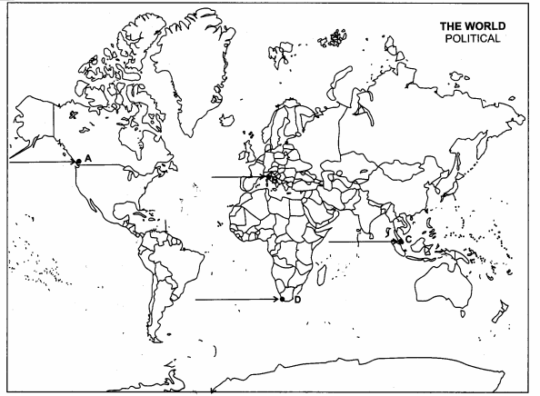
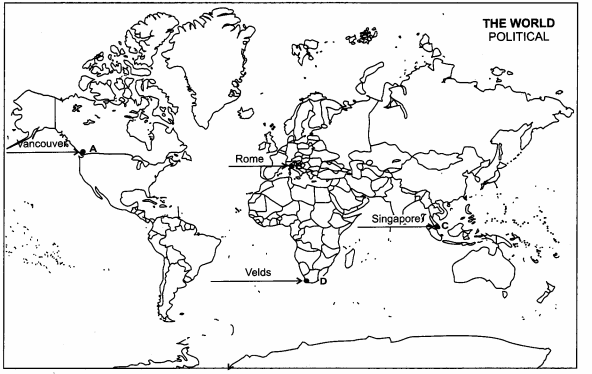
In the given political outline Map of the World, four features have been marked as A, B, C and D. Identify these features with the help of information given below and write their correct names on the lines drawn near them. [5]
(A) : A major sea port.
(B) : A major air port.
(C) : The country having the highest density of population in Asia.
(D) : An area of extensive commercial grain farming.

Answer:
26.1

Question 26.2.
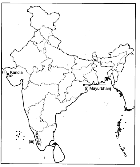
Locate and label the following on the given political outline Map of India with appropriate symbols:
(i) Mayurbhanj – iron ore mining area
(ii)A major seaport which has been developed after independence to cater the needs of Western and North-western parts ef the country.
(iii) A state having highest female literacy rate.
Answer:
26.2.

True
False
Question 2.
Mention any two key area of measuring ‘human development’. [1]
Answer:
- Health
- Education.
Question 3.
Name the terminal stations of ‘Australian trans-continental Railways’. [1]
Answer:
- Perth
- Sydney.
Question 4.
Define the term poverty. [1]
Answer:
A state or condition in which a person or community lacks the financial resources and essentials to enjoy a minimum standard of life and well being that’s considered acceptable in society. Poverty status in the United States is assigned to people that do not meet a certain threshold level set by the Department of Health and Human Services.
Question 7.
Name two rivers that provide water to Tata Iron and Steel company (TISCO). [1]
Answer:
- Kharki
- Swarnrekha.
Question 13.
Analyse three problems arising as a result of urban waste disposal. [3]
Answer:
- Localized environmental health problems such as inadequate household water and sanitation and indoor air pollution.
- City-regional environmental problems such as ambient air pollution, inadequate waste management and pollution of rivers, lakes and coastal areas.
- Extra-urban impacts of urban activities such as ecological disruption and resource depletion in a city’s hinterland, and emissions of acid precursors and greenhouse gases.
- Regional or global environmental burdens that arise from activities outside a city’s boundaries, but which will affect people living in the city.
Question 14.
Why is river Rhine the world’s most heavily used waterway ? Explain any three reasons. [3]
Answer:
The Rhine is an important waterway. Many goods are transported over the Rhine, and the Rhine valley is also an important wine producing region. The river Rhine begins at Tomasee, a lake in the canton of Graubunden in Switzerland and runs through Switzerland, Germany and the Netherlands. It is also the border between Switzerland and Liechtenstein and also the border between Germany and France. It runs through Basel, Bonn, Cologne and Duisburg. It also separates the cities of Mainz and Wiesbaden.
True
Question 18.
Give two advantages of Manganese. Mention any four main Manganese producing states in India. [3]
Answer:
Two advantages of Manganese are :
- It is considered an essential nutrient, because the body requires it to function properly. People use manganese as medicine.
- During the period of operation of the Merioneth manganese mines, the main applications were bleach manufacture, glass making and steel making.
- Manganese is used as a flux in smelting silver and lead ores. Manganese producing states in India are : Odisha, Karnataka, Maharashtra, Madhya Pradesh, Andhra Pradesh, etc.
Question 19.
Explain the role of ‘Market and ‘Transport’ in the location of industries in India. [3]
Answer:
The demand for market comes mostly from agriculture, industry and trade. The predominant form of industrial organization developed Market becomes K a necessary infrastructure for fast industrialization and hence it’s important for the economy because India is a land if agriculture where more than 7o % of population depends upon agriculture and as India is also an developing nation so, industrialization is most necessary.
: To: Development of any industry very much depends on good means of transport. To paraphrase: Development of any industry very much depends on good means of transport. All the production is meant for consumption from fields and factories. The product is brought from different places to market for consumers by various means of transportation.
True
Question 22.
Define the term ‘Tourism’. Explain any four factors that attract tourists in the world. [5]
Answer:
Tourism is the travel for recreational, leisure, family or business purposes, usually of a limited duration. Tourism is commonly associated with transnational travel, but may also refer to travel to another location within the same country. The World Tourism Organization defines tourists as people “travelling to and staying in places outside their usual environment for not more than one consecutive year for leisure, business and other purposes.”
Factors that attracts tourists are as follow :
- Destination is often characterized by pull factors; these are conditions that intensively attract someone to a place. Examples of pull factors are favorable environmental conditions, peculiar physical attractions, people’s culture and traditions, the tourism and hospitality industry of a place.
- Tourists always ask friends for destination recommendations when they plan their overseas trips. This also means that if a business owner wins a tourist’s heart, it will probably see more tourists visiting there shortly after.
- All of a sudden, group tours have been rendered less important by the rise of social media and online forums. Posts about travel destinations easily cause online buzz and have a strong influence on people’s decision-making. Independent travelers also heavily rely on online travel forums to plan their travel itineraries.
- Easy to reach becomes an increasingly important factor for tourists as they are seeking more exciting destinations on their trips overseas. No one wants to visit such a destination that is too difficult to reach. Tourists often avoid destinations in remote areas.